back to the project page:
Inhalt: Remote sensing tree analysis
Remote sensing provides the ability to determine plant characteristics at a large spatial scale to draw conclusions about the condition of vegetation. Temporal changes, e.g. in the context of phenological development (leaf emergence/leaf fall) as well as the effects of drought stress, can be mapped via observation time series from satellites. Therefore, in addition to the labor-intensive measurement campaigns to be conducted in CliMax at selected sites, airborne laser scan data as well as optical satellite imagery of the entire urban area will be included for the determination of urban tree vitality.
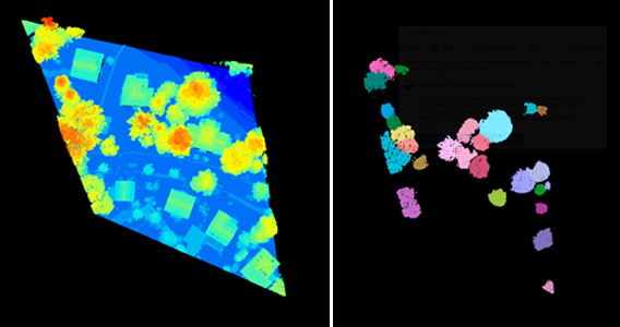
LiDAR systems provide high-resolution 3D information of objects in the form of a point cloud. The goal is to use this data for automated detection of urban trees to consequently determine structural parameters such as tree height or crown diameter and estimate biomass values. Challenges include the reliable separation of individual trees in dense stands and the correct classification of individual data points in densely built-up areas.
Spectral information from optical satellites will also provide information on the biochemical properties of urban trees. For example, a change in the spectral signal may indicate a lack of water in the plant, whose leaf chlorophyll content has decreased as a result. Accordingly, the goal will be to calculate spectral vegetation indices based on Sentinel-2 satellite image time series and use them as remotely sensed indicators of tree vitality. Heterogeneous urban structures and the relatively low spatial resolution of the Sentinel-2 data of 10x10 meters complicate the interpretation of the spectral signal. Therefore, various methodological approaches must be used to determine as accurately as possible the contribution of urban greenery to the reflectance signal.
In the context of this study, the tree registers of the city of Brunswick and Brandenburg an der Havel serve as reference and validation data.